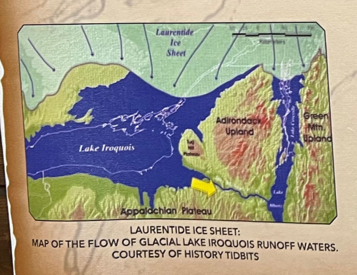
Today the Mohawk River flows from west to east. But that was not always true. In late glacial times, the glaciers left such a large amount of debris (sand, gravel, clays, silts) in the River valley that the River's flow to the east was plugged up. The water coming from the meltwater actually flowed westward. That was an easier path for the water to take since the land was lower to the west than it was to the east.
The picture below shows what the region looked like in late glacial times, after the Laurentide Ice Sheet had retreated north to approximately where the US-Canadian border is. The outline of Lake Ontario is within the boundaries of Glacial Lake Iroquois.
Eventually, the level for Glacial Lake Iroquois rose high enough that the water did start to flow east as indicated by the arrow. As the Lake drained over time, much of the debris from the glacier eroded and the River assumed its modern-day alignment and flow. Even today, though, the area around Rome, New York has significant sand deposits from the glacial deposits.

Further to the south where the letters "alach" of Appalachian Plateau are, the Finger Lakes exist. glacial times, when the Laurentide Ice Sheet was more extensive, the Finger Lakes were made deeper by the ice sheet's gouging them out.
In the area of Little Falls, about where the arrow is located, there are impressive late glacial features such as pot holesdolomitic limestones, carved in the bedrock. Here, either at the margin of the glacier or under the glacier, there were rushing streams that eroded the pot holes with swirling pebbles, cobbles and boulders.
But let's jump back in time from this most recent glaciation of 20,000 to 10,000 years ago to 325 million years ago. Why? Because today's Mohawk River flows along an important fault line at Little Falls. The fault line is known as the Fall Hill Ridge Divide. This fault caused the uplift of old, Precambrian-age quartzose syenite rock to the surface, forming the hard "Burnt Rocks" cliffs on the north side of the River and its riverbed. On the south side are the softer dolomitic limestones. These dolomites and limestones contain vugs or pockets where the quartzites were injected. Today, these are the so-called "Little Falls Diamonds", in reality, quartz crystals.
The fault line is part of a structural weakness in the Appalachian Mountains chain. It runs east-west and helps define the southern end of the Adirondack Mountains. It also defines where the Mohawk River flows along its fault line.
Little Falls, then, represents an important area of not only Paleozoic geology and ancient geologic structures, but also a place where, in late glacial times, the Mohawk River reversed and flowed to the west.
Cheers,
Brio


Comments